The River Trent
P. Ingall
P. Ingall
P. Ingall
A brief history of its navigation and uses
By Philip Ingall
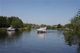
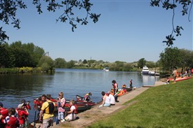
Today we walk by the River Trent at Farndon and get pleasure in watching pleasure boats cruising past or stopping for refreshment. The Farndon Marina houses a lot of those pleasure cruisers but what do we know about the river, its history and its role in transporting goods?
The name "Trent" comes from a Celtic word possibly meaning "strongly flooding". More specifically, the name may be a contraction of two Celtic words, tros ("over") and hynt ("way"). This may indeed indicate a river that is prone to flooding. However, a more likely explanation may be that it was considered to be a river that could be crossed principally by means of fords, i.e. the river flowed over major road routes.
One and a half million years ago the River Trent rose in the Welsh hills and flowed almost east from Nottingham through the present Vale of Belvoir to cut a gap through the limestone ridge at Ancaster and thence to the North Sea. 130,000 years ago a mass of stagnant ice left in the Vale of Belvoir caused the river to divert north along the old Lincoln river, through the Lincoln gap. In a following glaciation period the ice held back vast areas of water - called Lake Humber - in the current lower Trent basin. When this retreated, the Trent adopted its current course into the Humber.
Unusually for an English river, the Trent channel has occasionally altered significantly in historic times. An abandoned channel at Repton is described on an old map as 'Old Trent Water'. Further downstream, archaeologists have found the remains of a medieval bridge across another abandoned channel. The course of the river was altered in the area of Ingleby in Derbyshire when 300 acres was "moved" from one side of the river to another. This is recorded in Shakespeare's play Henry IV - Part 1:
The first improvement of the lower river was at Newark, where the channel splits into two. The residents of the town wanted to increase the use of the branch nearest to them, and so an Act of Parliament was obtained in 1772 to authorise the work. Newark Navigation Commissioners were created, with powers to borrow money to fund the construction of two locks, and to charge tolls for boats using them. The work was completed by October 1773, and the separate tolls remained in force until 1783, when they were replaced by a 1 shilling (now 5p) toll for whichever channel used. Improvements increased minimum depth from 2 feet to 3 feet.
In 1823 and again in 1831, the Newark Navigation Commissioners proposed improvements to the river, so that larger vessels could be accommodated, but the Trent Navigation Company were making a healthy profit, and did not see the need for such work.
The arrival of the railways resulted in significant change for the Company. Tolls were reduced to retain the traffic, wages were increased to retain the workforce, and they sought amalgamation with a railway company. The Nottingham and Gainsborough Railway offered £100 per share in 1845, but this was rejected. Tolls fell from £11,344 (£800,000 as of 2010), in 1839 to £3,111 (£210,000 as of 2010), in 1855.
In an attempt to improve the situation, the Company toyed with the idea of cable-hauled steam tugs, but instead purchased a conventional steam dredger and some steam tugs. The cost of improvements was too great for the old company. Two acts of Parliament were introduced in 1884 ans 1877 to restructure the company and raise extra capital but both failed.. A third Act of 1892 reverted the name to the Trent Navigation Company, and this time, some improvements were carried out.
With traffic still between 350,00 and 400,000 tonnes per year, and the company were persuaded that major work was necessary if the navigation was to survive.
A plan to build six locks between Cromwell and Holme, and to dredge this section to ensure it was 60 feet wide and 5 feet deep was authorised by an Act of Parliament obtained in 1906. Construction of Cromwell Lock began in 1908 and the Newark Navigation Commissioners financed improvements to Newark Town lock at the same time. Selling some 400,000 tons of gravel from the river bed financed the need for dredging the channel Cromwell lock could hold a tug and three barges, and was opened on 22 May 1911. The transport of petroleum provided a welcome increase to trade on the river, but little more work was carried out before the onset of the First World War.
Modernisation
Increased running costs after the war could not be met by increasing the tolls, as the company had no statutory powers to do so, and so suggested that the Ministry of Transport should take over the navigation, which they did from 24 September 1920. Tolls were raised, and a committee recommended improvements to the river. Nottingham Corporation invested some £450,000 on building the locks authorised by the 1906 Act, starting with Holme lock on 28 September 1921, and finishing with Hazelford lock, which was formally opened by Neville Chamberlain in June 1926. Newark Nether lock, was rebuilt and re-opened in April 1926.
Waterways nationalised
Trent Navigation Company ceased to exist in 1948, when the waterways were nationalised.
Having taken over responsibility for the waterway, the Transport Commission enlarged Newark Town lock in 1952, and the flood lock at Holme was removed to reduce the risk of flooding in Nottingham. More improvements followed between 1957 and 1960. The two locks at Cromwell became one, capable of holding eight Trent barges, dredging equipment was updated, and several of the locks were mechanised. Traffic rose from 620,000 tonnes in 1951 to 1,017,356 tonnes in 1964, but all of this was below Nottingham and a good part of it was the petroleum barges heading for Colwick.
Although commercial use of the river has almost ceased to exist, the lower river between Cromwell and Nottingham can still take large motor barges up to around 150 ft in length with a capacity of approx 300 tonnes. Barges still transport gravel from pits at Girton and Besthorpe to Goole and Hull. There is currently a movement to encourage a return of goods traffic on the river but lack of speed in transit against road or rail could well discourage this.
In the Newark Area there are three marinas with the largest one, constructed from former gravel pits, being at Farndon. More than 300 boats are moored at the three of them and most owners restrict their movements either up or downstream from Newark with few more experienced navigating into the Humber and out to sea or to visit either Hull or a little further up the estuary to Grimsby..
Navigation today
The river is legally navigable for some 117 miles. Down river of Shardlow, the non-tidal river is navigable as far as the Cromwell Lock near Newark, except in Nottingham (Beeston Cut & Nottingham Canal) and just west of Nottingham, where there are two lengths of canal, Sawley and Cranfleet cuts. Below Cromwell lock, the Trent is tidal, and therefore only navigable by experienced, well-equipped boaters. Navigation lights and a proper anchor and cable are compulsory. Associated British Ports, the navigation authority for the river from Gainsborough to Trent Falls, insist that anyone in charge of a boat must be experienced at navigating in tidal waters.
Experience is especially necessary at Trent Falls, a lonely spot where the Trent joins the Yorkshire Ouse, to form the Humber estuary. The timetables of flows and tides of the two rivers and the estuary are very complex here, and vary through the lunar cycle. Boats coming down the Trent on an ebbing tide often have to anchor or beach themselves (sometimes in the dark) at Trent Falls to wait for the next incoming tide to carry them up the River Ouse .
This article first appeared in the March 2014 edition of 'Farndon Focus' village newsletter, and is reproduced here by kind permission of the author and editor. www.farndonfocus.co.uk