In the footsteps of Nottingham's Domesday communities
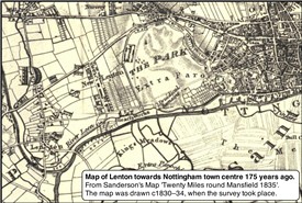
This map shows three existing routes between Lenton and Nottingham. Castle Boulevard (originally part of Lenton Boulevard) was not built until to 1880s.
©RHoward
Travel and transportation in and around Nottingham
By Robert Howard
When you journey around Nottingham, do you, just occasionally, wonder when the route was first established? In some cases, this is quite easy. Take the path beside the Nottingham Canal and Beeston Cut for example. The canal was constructed in the early-1790s and opened in 1796, so this route would not have been used before this date.
There is little or no firm evidence as to when people began to settle in and around Nottingham. At best, we have to rely on early documents for dates when local place names first appeared. The Anglo-Saxon Chronicle mentions Nottingham in 868AD. Many other local names are first recorded in the Domesday Book of 1086. The chances are that, by this time, all had existed for several hundred years. Some of the names in use at the time are of celtic origin, which could take them back to pre-Roman times. 'Leen' for example, as in the River Leen. Lenton and Linby both take their names from the River Leen. As I understand it, the first is old english and the latter old norse.
Over the years, there appears to have been occasional speculation about the course of historic routes between local settlements, but little or no systematic published research into the topic.
My interest stems from some involvement in the recording of historic rights-of-way in and through Lenton. I can go to Nottingham from my home in New Lenton via four fairly quite direct routes.
The map (right) shows how the area in the early-1830s. To the north I could have followed the Derby Road to the top of the hill (Canning Circus), then down the other side to Angel Row and the Market Square.
Then I could go down to what is now Park Road (then a trackway at best), which begins opposite the Grove Hotel and walk through the royal hunting ground (as The Park Estate once was), pass Nottingham Castle, onto Friar Lane and into the Market Square.
Finally, I could walk alongside the canal.
Today there is a fourth route along Castle Boulevard, which begins where Park Road meets Sherwin Road (part of the same route from Nottingham to Beeston) and runs north of the canal to Broadmarsh on the southern edge of Nottingham city centre.
I suspect that the route between Lenton as the castle is the oldest, as it is also on the line of the route which existed in 1760 between Lenton and Beeston*. In those days there was also a north–south route from the River Trent through to Radford and beyond.
Logic says that in the days when pack animals were more widely used than wheeled wagons, a track through the royal hunting grounds would have been preferable to climbing up and down the quite steep hills which peak at present-day Canning Circus. A lower route beside the River Leen may be fine in a small boat, but wet under foot and often muddy, if not marshy. I think it is a route I would have avoided. Am I right? In truth, I do not know, but it would be interesting to be part of a research project to try and map the most likely communication routes between Domesday Nottingham and the surrounding settlements and their subsequent development through the centuries which followed.
NOTE: * On the Nottinghamshire History website, there is a copy of a article, 'Lenton as an Open Field System', from the Transactions of The Thoroton Society, Vol.XL, 1936, which includes a section, 'Roads, Footways, Bridges and Fords', with particular reference to the year 1760.
There is also a series of articles on the website headed 'An Itinerary of Nottingham', complete with an linked index of all the streets included (published in the Transactions of The Thoroton Society during the 1920s and 30s).